Removing Freeways - Restoring Cities
Produced by the
Preservation Institute
Introduction:
Tear It Down!
by John Norquist
San Francisco, CA:
Embarcadero Freeway
San Francisco, CA:
Central Freeway
Milwaukee, WI:
Park East Freeway
Toronto, Ontario: Gardiner Expressway
New York, NY:
West Side Highway
Niagara Falls, NY:
Robert Moses Parkway
Paris, France:
Pompidou Expressway
Seoul, South Korea
Cheonggye Freeway
Freeway Removal
Plans and Proposals
Conclusion:
From Induced Demand
to Reduced Demand
by Charles Siegel
Seoul, South Korea
Cheonggye Freeway
In the 1970s, it was considered a symbol of progress when the Cheonggyecheon River in Seoul, Korea, was covered and a road and elevated freeway were built above it. But by the year 2000, the Cheonggye area was considered the most congested and noisy part of Seoul, badly in need of revitalization, and people agreed that nothing could be done to improve the area as long as the road and freeway remained.
When Lee Myung-bak was elected Mayor of Seoul in 2001, one of his key campaign promises was to remove this freeway and restore the Cheonggyecheon River. He developed a dramatic plan to remove Seoul's mone major freeway and to accommodate the displaced traffic by building a Bus Rapid Transit system and by cutting automobile use in half.
Lee’s election provided a mandate for the plan. The project to remove the freeway and restore the stream was completed in 2005, at the end of Lee’s four-year term as mayor. The project earned Lee the nick name of "Mr. Bulldozer" and made him a leading contender to become president of South Korea.
The History of the Cheonggyecheon
Seoul grew around the Cheonggyecheon, which divided the northern from the southern half of the city. The river was fed by tributaries flowing down from the mountains around the city – twenty-three tributaries, according to the early maps. The city’s major east-west road was along the Cheonggyecheon, its north-south roads along the tributaries, and its boundaries were the fortress walls connected the mountains around it.
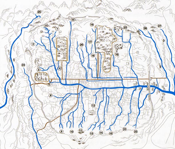
The Cheongyecheon and its Tributaries
These rivers were often dry in the spring and fall, when there is little rain, and they tended to flood during the summer rainy season.
Between 1406 and 1412, King Taejong deepened and widened the river and built dykes to control the flooding; in 1412, 52,800 people worked to build stone embankments and stone bridges over the Cheonggyecheon and its tributaries. His successor King Sejong continued this work, digging ditches that diverted some of the water from the tributaries, to prevent flooding in the city.
This was when the stream got its early name, the Gaecheon, which means “digging out.” At first, this was the name of the project of improving the stream, but then it became the name of the improved stream itself.
King Sejong’s advisors had two opinions about the use of the Cheonggyecheon. The idealists believed that the water should be kept clean, following the principles of Feng Shui. The realists believed that the growing city needed a waterway to carry out its sewage, and the Cheonggyecheon was the only option.
King Sejong finally sided with the realists and opened the Cheonggyecheon for use as a sewer. For the 500 years of the Joseon Dynasty, the tributaries supplied the city with clean water, and the Cheonggyecheon washed away its wastes.
By 1657, the population of Seoul had grown to over 190,000, and the Cheonggyecheon could no longer accommodate the city’s sewage. From 1760 to 1773, King Yeongjo mobilized 50,000 workers to dredge the river and to build new embankments and dykes, accommodating the increasing population.
During the Japanese occupation, the Chongyecheon got its current name. The new name probably originated in 1914, when the Japanese compiled a list of Korean river names, and by 1916, this name had completely replaced the name Gaecheon. Cheonggyecheon means “clear water stream,” but the Japanese sometimes called it the Takgyecheon, which means “dirty water stream,” because the river had degenerated into a polluted sewer.
Beginning in 1925, the Japanese covered many of the Cheonggyecheon’s tributaries, converting these rivers into covered sewers as part of a project to create an underground sewage system for Seoul.
The Japanese also developed several plans for covering the Cheonggyecheon. In 1926, they announced a plan to cover the river to create new land for development. In 1935, they announced a plan to cover it with a roadway with an elevated railroad over it. In 1939, they announced a plan to cover it to create a road for cars. In 1940, they announced a plan to cover it and built a tram on the surface and a subway underground.
All these plans failed because of lack of funding, as Japan poured all its resources into the Sino-Japanese war. The Japanese covered only a small section of the river in 1937.
After the end of World War II, South Korea developed plans to dredge the Chonggyecheon, which had become badly silted because the Japanese neglected its maintenace during the war, but these plans were interrupted by the Korean War. Refugees from the Korean War flocked into Seoul, and many settled on the Chonggyechon.
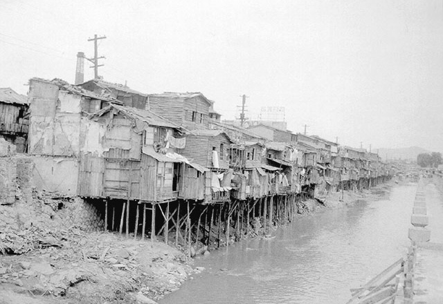
Refugees from the Korean War built Huts on the Chonggyechon.
In the mid 1950s, the Chonggyechon was considered a symbol of the poverty and filth that were the legacy of a half-century of colonialism and war. The open sewer in the center of the city was also a major obstacle to the redevelopment of Seoul. At a time of extreme economic hardship, the only way of dealing with this problem was to put the stream underground.
The stream was undergrounded in a four-stage construction project, beginning in 1955 and ending in 1977. An elevated freeway was built above most of the underground stream between 1967 and 1971; this freeway was four-lanes wide and over three miles (5,864 meters) long, and it ran above a conventional roadway.
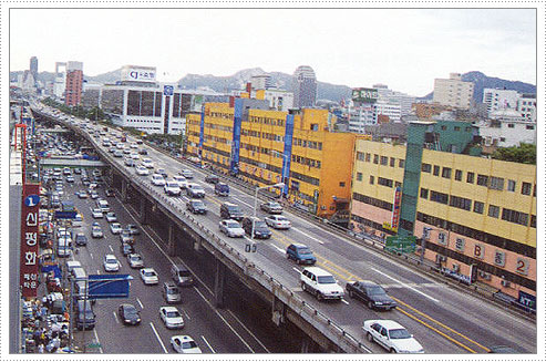
The Chenoggye freeway ran through the center of Seoul
The huts were removed from the banks of the stream, and their residents were forcibly relocated. In their place, modern stores and an industrial center were built there. This redevelopment project became a symbol of the modernization and industrialization of post-war Korea.
Removing the Freeway, Restoring the River
But four decades after it was covered, the Cheonggyecheon area had become a shabby industrial area, filled with flea markets and tool, lighting, shoe, apparel, and used book stores. As an agency to promote Korean tourism said, “People no longer think of Cheonggyecheon as the pride of Seoul. Rather, it has become thought of as the most crowded and noisy part of Seoul. … The enormous concrete structure forming the Cheonggye Overpass, once a symbol of modernization and industrialization, has become an eyesore born out of Korea's drive in the 20th century to the industrialize at all costs.”
The area was badly in need of improvement, but everyone realized that there could be no significant change as long as the freeway remained.
When Lee Myung-bak ran for mayor of Seoul in 2001, one of his key campaign promises was to remove the Cheonggye freeway and restore the river in order to revitalize the area economically. Lee had been the CEO of Hyundai Engineering and Construction, and one of the project’s goals was to make Seoul into a hub of Northeast Asia by attracting tourism and investment from multinational companies and international organizations.
Despite some opposition from businesses that were closed to allow the demolition, the project was supported by the overwhelming majority of Seoul residents. According to a survey conducted by the city government, 79.1 percent of residents supported the plan.
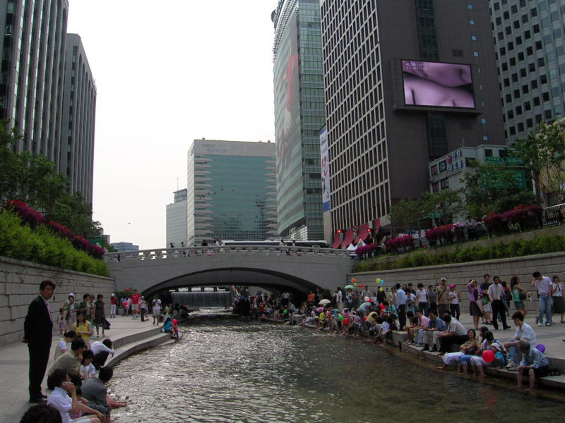
The restored Cheonggyecheon flows through the center of Seoul.
Lee did not waste any time implementing this project. He was elected mayor in June, 2001. A master plan from stream restoration was completed in February, 2003. Freeway demolition began in June, 2003 and was completed in September, 2003. Stream restoration began in July, 2003 and was completed in September, 2005, at about the same time that Lee’s four-year term ended. Several million people came to celebrate the opening of the restored river.
In March, 2003, Seoul began constructing its first Bus Rapid Transit line, which serves the route of the freeway and is designed to accommodate the drivers of the 120,000 cars that used the road every day. The 14.5 km BRT corridor was completed in June, 2003, at the same time the freeway was closed. In addition, Seoul announced that it would improve bus service in eighteen other corridors, with exclusive bus lanes on nine of those corridors.
This BRT system is planned as a complement to Seoul’s underground metro system. It would have been too costly and too time consuming to extend the metro system as part of the freeway demolition plan, but integrating the new BRT with the existing metro system gives the city a way of adding transit capacity quickly as it is transformed to become less automobile-oriented.
This planning is being coordinated by the Seoul Development Institute (SDI), which is funded by the city. SDI Director, Dr. Gyeng-Chul Kim, has set the goal of replacing all diesel buses with natural gas powered buses and cutting the use of private vehicles by more than half, from 24% of all trips to 12% of all trips.
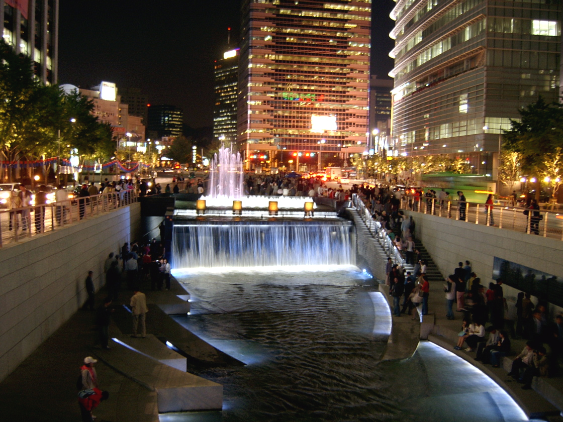
The restored Cheonggyecheon at night.
The restoration of the the Cheonggyecheon has become a source of tremendous pride in Seoul. On its web site, the city says about this plan:
“Once the historical site is restored, Seoul will regain its 600-year history as the capital of Korea by turning itself into a city where the modern era is wonderfully amalgamated with tradition. The restored Cheonggyecheon area is expected to become Seoul’s major tourist attraction for both Korean and overseas tourists. The project will be focused on improving the environment both for living and business, and is expected to make a major contribution to realizing Seoul’s plan to become the financial and commercial hub in the East Asian region. The new look of Seoul is also expected to create a new hope for Seoul citizens.”
Lee was elected South Korea's president in December, 2007, and a New York Times article about the election began by saying:
"The man chosen as South Korea’s next president in Wednesday’s election owes much of his victory to a wildly successful project he completed as this city’s mayor: the restoration in 2005 of a paved-over, four-mile stream in downtown Seoul, over which an ugly highway had been built during the growth-at-all-cost 1970s. The new stream became a Central Park-like gathering place here, tapped into a growing national emphasis on quality of life and immediately made the mayor, Lee Myung-bak, a top presidential contender."
A Model for Asia
This plan in Seoul is bound to be a model for the rest of Asia in the future.
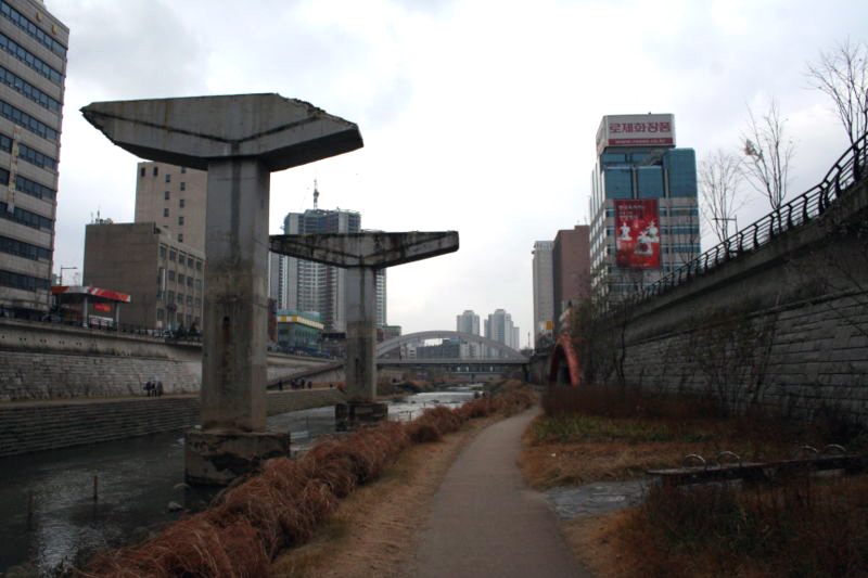
To symbolize its history, some freeway supports were left in the restored river.
During the last decade, China has embarked on a binge of freeway building, and it now has the second largest freeway network in the world, with only the United States having more mileage. Major Chinese cities are criss-crossed with of elevated freeways, as are other Chinese cities.
China today is in the same situation that Korea was in during the 1960s, when the Cheonggye freeway was built. Because the automobile culture is just taking hold there, freeways still seem like a symbol of progress and modernization. And because only a small percentage of people own cars, the traffic has not ground to a halt.
As the number of drivers in China increases, it is bound to learn what Korea has learned. The automobile simply can never work as the major form of urban transportation for cities that are as dense as Asian cities, which are more than twice as dense as European cities.
The automobile does not work in such dense cities because there is not enough room for all the cars. One express-train track carries about as many passengers as ten lanes of freeways, and cities this dense have enough room to provide enough public transportation for everyone but do not have enough room to provide enough freeway lanes for everyone.
The automobile does not work in such dense cities because there are more important uses for scarce land. The land used for a single freeway that carries a small fraction of the city’s traffic could be used instead for public spaces that are a major enhancement to the city’s life.
As the number of drivers in China increases and traffic becomes more and more clogged, the Chinese will stop seeing elevated freeways as symbols of modernization and will start seeing them as the most crowded and noisiest parts of their cities. The Chinese view of freeways will change, just as the Korean’s view of the Cheonggye freeway changed in the forty years after it was built, and the Chinese will look to Seoul as a model of how to improve their cities by tearing their freeways down.
Text copyright 2007 by The Preservation Institute